Thursday, November 10, 2011

Herepai Hut

These pictures were taken on an overnight trip to Herepai Hut in the Northern Tararua’s.

It only took me about 3 hours to reach the hut from the road end, so would normally have done this as a day trip, but given that I started out fairly late in the afternoon decided to make it an over-nighter.

The track up to the hut follows a river for a while via a couple of swing bridges before climbing up steeply to a junction where I turned right and reached the hut after another 40 minutes or so.

The hut is situated a little below the tree line and the plan was to get up onto the tops the next day and take some pictures. I woke up the next morning to find cloud building up on the tops, and with the wind also getting up, decided to walk straight back out to the road end.

The weather really deteriorated on the way down so coming back early was a good move. A nice pleasant walk all the same.


The route


There were two of these to cross


The junction


Me at the junction


Herepai Hut


The weather really deteriorated on the way back

Tuesday, November 8, 2011

Uk and Spain 2011

In September this year Neena and I nipped over to the UK on what has now become our traditional bi-annual trip to visit friends and family. For a number of reasons I was more than a little down on coming over this time. Partly this is down to my rather pessimistic nature but also for a variety of other reasons that I will keep to myself.

Anyway, surprise, surprise both of us had a terrific time, with this particular trip certainly being Neena’s favourite and quite possibly mine as well. This was entirely due to friends and family who were all wonderfully hospitable and friendly – many thanks.

Every time we fly we always do our utmost to find the cheapest possible airline regardless of the level of service, safety or anything really. This year we outdid ourselves and got a really cheap deal with Brunei Airlines. In this instance I feel we took things too far as the journey over to Blighty took over 50 hours with substantial stopovers in Auckland, Brunei and Dubai. The longest stopover was 14 hours in Brunei, which we put to good use by booking ourselves onto a tour of the capital Bandar Seri Begawan. Brunei is a very small country sat on a very large amount of oil and is an absolute monarchy ruled over by the Sultan of Brunei. Judging by the number of gold plated palaces and mosques the Sultan appears to lead a very opulent lifestyle, but he has also had enough sense to spread the oil money around a bit. Health and education are free as is petrol just about, at just 10c a litre! The result of this is a population of 400,000 owning 1.2million cars, which I actually find a little bit sad (we didn’t see a single pedestrian on our tour). Architecturally Bandar Seri Begawan is pretty undistinguished with lots of bland low-rise buildings though the outstanding palaces and museums certainly warrant a visit.

Incidentally, Brunei Airlines were very good but I think we learnt our lesson this time as for just a few hundred dollars more we could have got a quicker and more direct flight to the UK. Sometimes cheap isn’t always good value.

The Sultans shed.


After what seemed like several eternities we arrived in the UK with surprisingly little jetlag and threw ourselves into the social whirl visiting friends, family and in particular my nephew Thomas whose birth we had missed by a couple of days on our last trip over.

Other than the chilling out in Harlow seeing the aforementioned friends and family we also found time to visit Barcelona as well as spend a week tramping with friends in the Lake District.

The trip to Barcelona was originally going to be a trip to England’s South Coast. We were going to hire a car and visit Brighton, and if we could handle the sensory overload, Hastings as well. After a bit of research we realized that flying down to Spain would be no more expensive than hiring the car, so off to Barcelona we went. Good choice as it turned out, as the city in general and the Gaudi architecture in particular were really stunning and this combined with the warm weather made for a very enjoyable few days. Rather than join a tour we spent the time walking around the city, which is certainly the best way to see things, and in this instance borne of necessity as neither Neena’s travel card nor my credit card would work in the local ATM’s meaning we were running on a pretty tight budget. We were pretty well broke by the time we got back on the plane. Barcelona comes highly recommended and is likely to be high on our agenda come our next trip over.


Park Guell


Sagrada Familia – they started building this in 1882 and are still going


At the top of a hill waiting for a fountain to light up (it never did)


Barcelona at Night


This market reminded me of the Souks in Morocco


We had but a couple of days back in Harlow before heading off to Wasdale Head in the Lake District where we stayed for a week in a cottage at Bowderdale Farm (http://www.bowderdale.co.uk/) with some friends, namely Robin, Kevin, Eddie, Dai and Lucy the dog. The accommodation was nice and rustic with lots of stone walls and exposed beams and could hardly have been any better - many thanks to Kevin for that one.

Apologies one and all, but the account below has written mostly from my rather shaky memory and consequently may be a tad inaccurate, though hopefully not to wrong. If you spot any errors then feel free to comment and I will endeavor to put things right.

Lucy is a Border Collie and proved to be great fun on the trip with her irrepressible energy and playful nature. She did tend to get a little overexcited whenever we got ready for a tramp which mostly consisted of nipping whoever’s ankles were nearest, although she nearly relieved me of my shorts on one particular occasion. While out on our walks Lucy would constantly run back and forth which was basically her idea of herding us, though strangely had absolutely no interest in doing the same with sheep.

Our first walk was on Sunday and started from the National Trust Car Park at Wastwater. From here we headed through Wasdale Head Farm and up a steady climb onto the Bluffs on the southern side of the lake passing over Nigill Head and Whin Rigg. From here the original plan had been to turn left and head back via Tungue Moor. Being the first day a number of us hadn’t found our “tramping feet” and were feeling rather tired and it dawned on us that going via the Moor would lead to a pretty long walk, with another climb right near the end. This being the case, we instead turned right and headed down a path that ran along Greathall Gill and ended up a the far end of Wastwater and a walk back along the road to the car and beer.


Neena, Eddie and Dai high above Wastwater


Wastwater


On Monday we did an easier low-level walk in the Eskdale Green area. I can’t for the life of me remember the route, particularly as we got slightly lost at one point, so you will just have to use your imagination. One particular highlight was lunch at a local Pub where I had the most divine Bread and Butter Pudding, which ranks up there as one of the very best desserts I have ever had, and which was allegedly cooked by the Queens Pasty Chef herself. I could well believe it.


Robin, Dai, Eddie, Kevin and Me in Bread and Butter Pudding Heaven


On Tuesday Neena, Kevin, Lucy and myself decided to do the tourist thing and visit Lake Windemere via the appropriately named Hardknot Pass. Lake Windemere was much as I expected with lots of tourists and tramping shops as well as quite a few homicidal swans. We sat down by the Lake edge for a spot of lunch and Neena made the mistake of feeding said swans. Unsurprisingly, from this point on they wouldn’t leave us alone and crowded around expecting more food. They particularly didn’t like the dog who was roundly hissed at. The normally fearless Lucy decided, like most Generals, to lead from rear, which in this case consisted of hiding behind Kevin.


Homicidal Swans


The thing that sticks in the mind the most is the Hardknot Pass which is reputedly Britain’s steepest road. It must also be in places the narrowest and most poorly maintained and I reckon barely even qualifies as a road at all. Once I got over the shock, it was great fun to drive even if it felt more like an assault course than a public highway. At one point I started to drive up one of the steeper sections in too a higher gear (2nd) so had to change down to first. At this point the front wheels lost traction resulting in lots of smoke and not a lot else, leaving me no choice but to slide back to the bottom of the hill. I had two other unsuccessful attempts at getting up the hill, before figuring out that what was needed was to reverse a decent way back, floor it and let the cars momentum and limited grip carry us up and over the brow of the hill. The brow of the hill was almost as steep on the other side meaning that I had no idea until I got over the top if anyone was coming the other way. Incidentally the track, sorry road, was also single lane at this point!


At the top of Hardknot Pass


On Wednesday my friend Nick, who lives relatively nearby in Stockport, joined us for a walk along the “Corridor Route” which Robin rightly claimed was one of the best day walks in the Lakes.

We parked up at Wasdale Head Inn and followed a path which ran upstream beside Lingmell Beck up to Sty Head. From here we hung a right and walked what is known as the Corridor Route which for several miles traverses over steep ground requiring some minor scrambling before arriving at the top of a Col which marks the start of Lingmell Gill. This proved to be quite a tough trek and by this point Neena and I were lagging well behind the others. We were in no rush though, particularly as the weather was absolutely superb. From the top of the Col we followed a path down the Gill before hanging a right just after a stone wall. From here the track lead us back down to the pub and a well-deserved beer.


Heading up Lingmell Beck


Nick and myself near Sty Head


Sty Head Tarn?


This one was taken somewhere on the Corridor Route


The following day Robin, Dai and myself walked up to Haycock and then onto Red Pike. We started from Bowderdale Farm and climbed steadily for an hour or so following Nether Beck before climbing up to a Coll from where we turned left and headed on up to Haycock. This was the only day in the Lakes where the weather let us down. By the time we reached the Coll we were up in the clouds and the wind, making it more than a little chilly, particularly as I had forgotten to take my hat and gloves. The summit of Haycock was pretty indistinct and given the weather there wasn’t much to see, so we didn’t linger long and quickly retreated down the Coll. From here we followed a rock wall, which was supposed to lead onto a ridge that would eventually lead onto Red Pike, via Scoat Fell. We had a few route finding issues in the mist but eventually made it Red Pike, at which point the cloud started to lift and the weather became a lot more pleasant. From Red Pike we descended down to Dore Head where wee turned right onto a track which ran alongside Over Beck and which eventually led us back to Bowderdale Farm. Very much a game of two halves this one, as the first part of the walk was a bit grim but the remainder was very nice indeed with some great scenery. Another added bonus, for me at least, is that we saw very few other walkers, which is just the way I like it.


Out of the cloud at Dore Head


The plan on the last day was for the group to climb up to Scafell. At the last moment Kevin and I had a change of mind and decided to climb the nearby but separate peak of Scafell Pike. There are a couple of reasons for this.

The first is that the Pike is the highest peak in England whereas Scafell is merely the second highest, and maybe its just a guy thing, but we decided biggest is best.

The second reason is unfinished business. I climbed the Pike about 30 years ago in atrocious conditions and didn’t get any kind of view, on top of which, such was my haste to get back down again I am not even sure I did get to the very top.

Kevin and I took the main tourist route up to the top but did lengthen the trip a fair bit by walking directly from the farmhouse. The track up was very steady and a great way of gaining height, so much so that we made the top in a couple of hours. The views from the summit were superb even it was a bit busy with other walkers. The weather was really hot for the time of the year and allowed us to have a nice leisurely lunch on the summit in shorts and tee shirts and was a nice finale to what had been a terrific trip to the Lake District.


On top of the world, or England at least


Many thanks to Robin, Eddie, Kevin, Dai, Nick and Lulu for their wonderful company and we will look forward to seeing you guys next time round.


Friday, April 29, 2011

South Island Motorcycle Odyssey

These pictures were taken on a 9-day motorcycling trip to the South Island.

As is usually the case when I go away the weather was mostly terrible and an ark would have been far more suitable transport than a motorbike. I traveled south down the west coast before heading off over the Haast Pass and onto Te Anau. I stayed here for a couple of days and took the opportunity for take a boat trip to Doubtful Sound in the Fiordland National Park. From this point I started to head north again and over the next few days traveled up to Twizel and then onto Murchison via the Lewis Pass. The weather on this part of the trip was glorious, and this combined with some of New Zealand’s best scenery and biking roads, made for a tremendous couple of days. After a spot of white water rafting at Murchison I headed off to Nelson and then eventually onto Picton and the ferry back to Wellington. The rain returned with a vengeance on these last couple of days and I was well glad to get back home again.


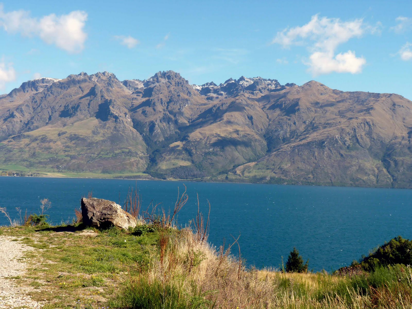
On the west coast just before heading over the Southern Alps via the Haast Pass.


At the top of Haast Pass.


Camping at Kingston. Alas not the Jamacain one. Still, at least the snow made a change from the rain.


Kingston again.


Looking over Lake Manapouri.


Lake Te Anau.


On the way to Doubtful Sound, the first part of which involves a 50min boat trip across Lake Manapouri.


Lake Manapouri power station. This is the largest power station in the country and is capable of powering every house in the South Island, but which is actually used to power a single alluminium smelter.


The turbine hall is situated in a cavern which is located 200m underground. After visiting the hydro station it was onto a coach for an hours trip over the mountains to Doubtful Sound.


Doubtful Sound. The weather was just horrible with non-stop rain so I didn't take that many pictures. The Fiords receive up to 9m of rain a year, so this is pretty normal.


Doubtful Sound.


Doubtful Sound seal colony.


Spot the seal.


At least the rain in the Sound meant there plenty of these.


Lake Wakatipu near Queenston. This was on the way to Twizel and was on the best day of the trip weatherwise.


Lake Wakatipu again.


Ditto.


The man in leather.


This and the next one were taken near Mt Hutt on the eastern side of the island. To get there I had to cross over the Alps via the Lewis Pass. The road over the pass is in my opinion about as good as it gets in motorcycling terms with loads of wide sweeping bends, amazing scenery and very few cars.


Just lovely. Unfortunately the weather went rapidly down hill from this point.


I had had enough of the rain by this stage and couldn’t face another night camping so stayed in this 1970’s era caravan at a holiday park near Nelson for a bargain $30 a night. The park and caravan come highly recommended.


Friday, March 11, 2011

Sydney

This was actually a business trip, but I found some time to do the tourist thing.


Monday, February 28, 2011

Mitre Tramp

The target of this trip was to climb Mitre, which at 1571m is the highest peak in the Tararua range. 

It wasn’t intended that way, but this turned out to be a solo trip. I don’t much enjoy tramping on my own mostly due to safety reasons, and even after all these years up in the hills, my appalling sense of direction. A combination of fine weather, a free weekend and no one else being available made up my mind for me. I got fairly close to the summit a few years ago but turned back about 40 minutes from the top due to the usual horrible weather. 

I sneaked of work early on Friday afternoon and drove the 80km or so to the “Pines” roadend in the Tararua Forest Park. I left the car there and walked to Mitre Flats Hut where I stayed the night. The track to the hut stays close to and somewhat above the Waingawa River and is only about 8km long and involves no big climbs, but takes a solid 4hrs to complete. For the first 20 minutes or so the route follows a gravel road and is a nice and pleasant start of the walk. Before long the track entered the bush and the going became much harder due to the constant rise and fall of the track and the relentless battling with tree roots and rocks. The weather was really hot as well and it was a relief to arrive at a sign telling me I was 8 minutes away from a swing bridge which leads on to the hut a further 5 minutes away on the other side of the river. Mind you there was a really steep drop of around 80m down to the bridge, so it seemed like a very long 8 minutes. I arrived at the hut to find out that I was the only one there. Despite not liking tramping on my own I was well pleased to have the place to myself. As it was getting dark, all that was left to do was cook dinner and then head of to bed. 

I was up bright and early the next day, had a quick breakfast and was on my way by 0630. The reason for the early start was in order to beat the heat of the day and also to give myself a better chance of arriving at a cloud free summit. This is a real consideration as the summits are only cloud free for about 80 days a year. 

The track to Mitre starts about 5 minutes walk from the hut and climbs steadily up to the treeline at about 1100m. I had expected to struggle on this section of the walk, but the track was well marked and I am fitter than I have been for a while, so made it up to the open tops in under 2hrs. 

From this point the views were pretty spectacular, but the track was also more difficult to follow, as it is not officially marked above the tree line. Previous trampers however had built up a series of small rock cairns which marked the way and weren’t too difficult to follow, particularly once I became attuned to spotting them. After climbing for another 20 minutes or so Mitre came into view, which was a welcome sight. A less welcome sight was the cloud starting to build up just above the summit and which spurred me on to a real turn of speed to make it to the top, which in the end I reached in just under 3 hours and which for me is pretty good going. 

As mentioned before the Tararua’s have a reputation for really foul weather, but here I was on the summit in a tee shirt, in the sun, and with hardly a breath of wind. I had time for a quick lunch and a few pictures before the cloud really starting coming down and with the visibility getting poor I decided it was time to make my way back down to the hut. 

I arrived back at the hut at about 1pm, which is way earlier than I thought I would. 

The original plan was to stay there for another night and then walk out the next day, but I didn’t really fancy hanging around and was still feeling pretty good so made a snap decision to carrying on walking out to the roadend. In retrospect this was a poor choice, as after an hour or so I started to feel rather tired and still had a long way to go. This meant that a lot of the time I was pretty well walking on autopilot and probably wasn’t paying as much attention as I should. 

Midway through the walk I inadvertently stepped to close to the edge of the track and started to quickly slip down a very steep bank. Instinctively I grabbed out for a passing tree route, which happened to flash past. I only just caught it and managed to scramble the few metres back onto the track. Looking back at where I fell was a real shock as the slope was about 60° or 70° and the tree root was the last piece of vegetation between me and the Waingawa River several hundred metres below. This really shook me up and could have turned out very differently, and hopefully is a lesson well learnt. 

The flirt with the grim reaper aside, this was a terrific trip and has spurred me on to have another go at bagging the North Island's two highest volcanoes, Mt Taranaki and Mt Ruapehu later on this year.

This was taken near the roadend showing the Wainagawa River

View from the Mitre Flats track. The swing bridge.
5 minutes to the hut.
Mitre Flats Hut.
I had the place to myself.
On the way up to Mitre getting close to the bush line.
Up above the bush line.
Looking towards Mitre.
Getting a bit closer.
This was taken from the narrow exposed ridge which leads on to the summit. Not somewhere to be on a windy day.
Mitre summit.

Mitre 360°.